Review: Hurricane, written & illustrated by Jason Chin
- amiller8979
- Jul 15, 2025
- 3 min read

Updated: Aug 18, 2025
by: Amber Miller
July 15, 2025

It’s a beautiful day on Hatteras Island, North Carolina. But while all seems calm now, a hurricane is barreling across the Atlantic, and everyone is wondering when it will hit the U.S. coast. And where.
Jason Chin's latest takes us to one of my favorite places on Earth, Hatteras Island (off the coast of North Carolina), where the anticipation of a brewing storm in the Atlantic is building. After engaging and capturing readers’ interest with a dramatic cover depicting crashing waves against the dunes and a line of evacuating cars, Chin's opening pages feel more like an action movie trailer than an informational text reading:
A storm is raging over the Atlantic Ocean. Its terrible winds whip up waves taller than houses. Torrents of rain pummel that water's surface. Lightning and thunder split the sky. A weather buoy measures 85 mile-per-hour winds. This is no ordinary storm. This is a.....
HURRICANE
Now that the reader's interest is thoroughly piqued, Chin gets down to the business of educating the reader on what a hurricane is by defining a hurricane and describing the early tracking measures taken by meteorologists at the National Hurricane Center in Miami who are studying the impending storm. The countdown begins.
Chin's examination of a hurricane (based on several real ones that I vividly remember) is brilliantly told in segments alternating between the pre-storm preparations of island residents and those of scientists.
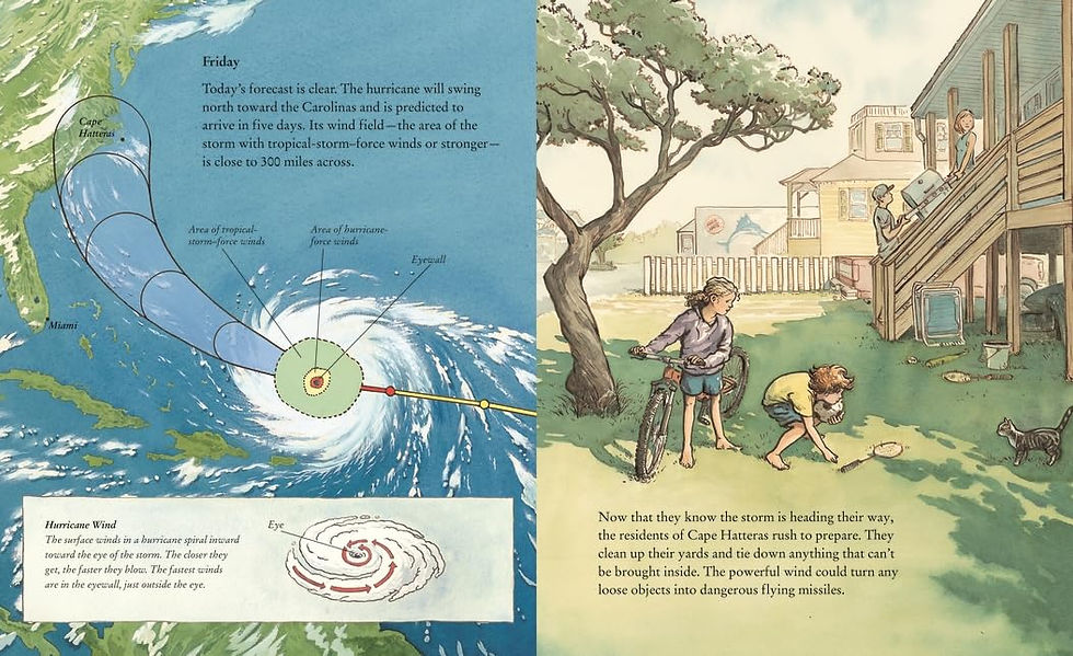
On Monday, the storm forms off the coast of Africa and moves west across the Atlantic as residents warily continue with their daily activities. On Tuesday, scientists follow the storm’s path; residents begin discussing arrangements. On Wednesday, forecasters work day and night to predict the storm's track with the help of the elite Hurricane Hunters. On Thursday, the hurricane is classified as a major Category 3 storm. On Friday, the residents of Cape Hatteras rush to prepare. And so on, until Wednesday, when the climax occurs when the storm makes landfall. Chin uses short narrative descriptions and spot art to depict what is happening on shore: the rising surf, the destructive winds, the calm of the eye, and the hurricane’s return with its change in wind direction. And then it’s over, but the work has just begun. Island residents return home and help one another with the cleanup.

Chin masterfully juxtaposes the experience of people affected by the hurricane with the larger scientific context; stunning illustrations in pen and ink, watercolor, and gouache bring life to massive weather phenomena and to smaller-scale scenes. The extensive back matter offers valuable insights into storm formation, meteorology, and forecasting. An author’s note addresses concerns about the importance of the meteorological community’s work and the effects of climate change.
As a coastal Virginia native who has lived through many hurricanes, I can confirm that one of the most exciting aspects of an impending storm is tracking it, and that there is nothing more deceivingly tranquil than being in the eye of the storm. However, the most critical messaging can be found in Chin's Author Note at the end of the Novel. Suggested sources for further inquiry conclude this outstanding book, which is my favorite non-fiction text of 2025 so far.

Chin's illustration of "the stretch" is particularly meaningful and significant to the residents of the island and all who have visited, as it is the only road that provides vehicle access to and from Hatteras Island in North Carolina, specifically North Carolina Highway 12 (NC 12). NC 12 is a two-lane highway that spans the length of the island from Oregon Inlet to Hatteras Inlet, connecting the island to the northern Outer Banks via the Marc Basnight Bridge. This dependence on NC 12 makes Hatteras Island vulnerable to the effects of storms and rising sea levels, which can lead to closures and isolation. During his author visit to Hatteras Elementary School, Chin shared that when he shared the book with students, "all the kids yelled 'the stretch!!!' when they saw it".
The months for hurricane season in the Atlantic basin are June 1st to November 30th, according to the National Hurricane Center. While the season officially spans these months, the most active period, or "peak season," is generally from mid-August to late October, which makes Hurricane the perfect late summer to early Fall read!


Comments